Township Road Map
Bloom Township, Fairfield County, Ohio
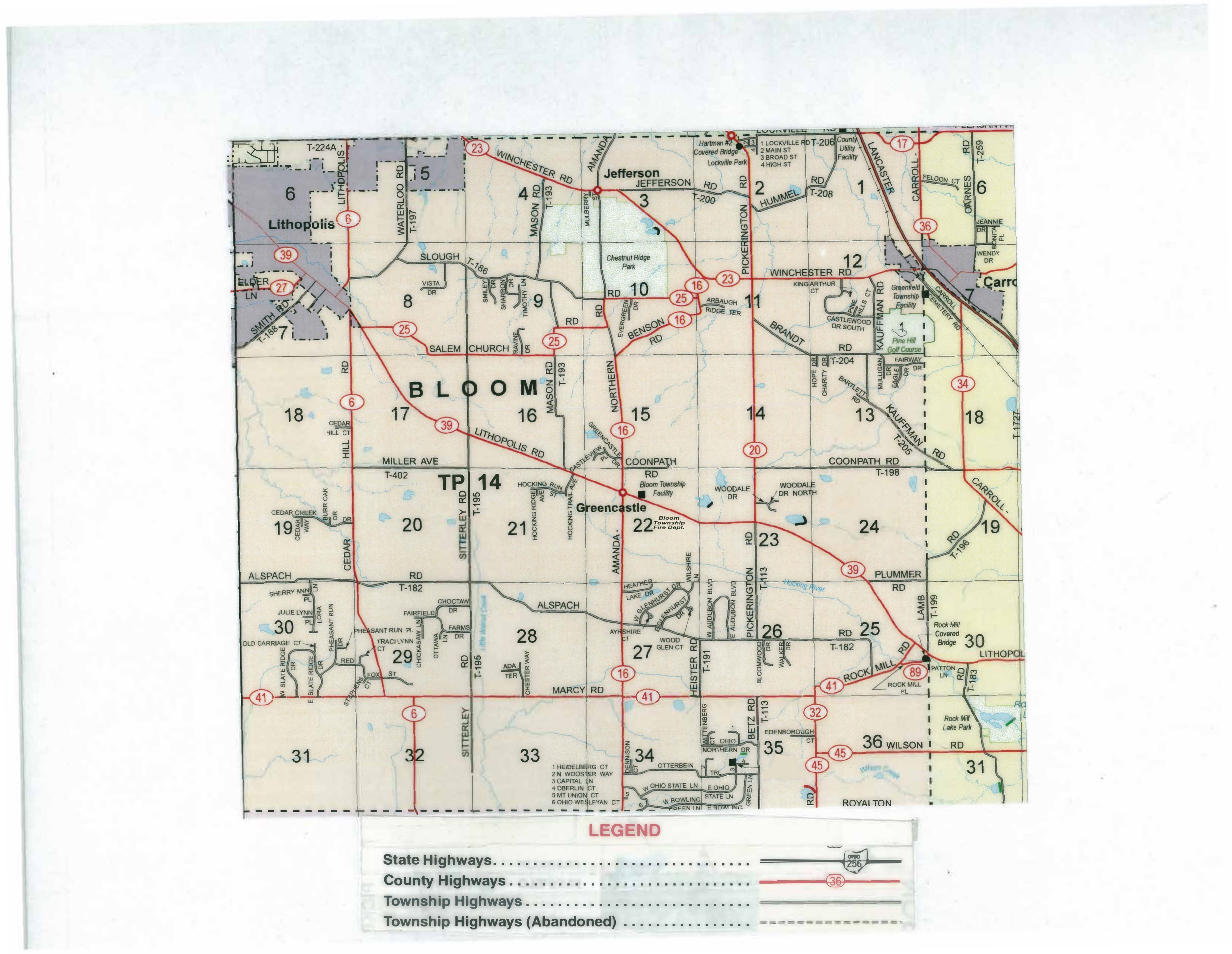
Text description of the map
This is the official highway map of Bloom Township in Fairfield County, Ohio. It shows how the township is divided, the roads that run through it, the communities within and around it, and notable parks and public buildings. The descriptions below move roughly from the top of the map (north) to the bottom (south).
How the map is organized
The township is drawn as a grid of 36 numbered survey sections, the standard layout for an Ohio township. Section numbers run in rows: 6 through 1 across the top, then 7 through 12, then 18 through 13, then 19 through 24, then 30 through 25, and finally 31 through 36 along the bottom. Large letters spelling “BLOOM” and the label “TP 14” (Township 14) sit across the middle of the map. Roads are colored by type, explained in the legend.
Communities on and around the map
- Lithopolis — a village in the northwest corner, shown shaded.
- Jefferson — a community near the top center.
- Greencastle — a community at the center of the township, near the Bloom Township offices and fire department.
- Lockville — at the top right edge, with Lockville Park and the Hartman #2 Covered Bridge nearby.
- Carroll — a village at the east (right) edge, toward Lancaster.
- Royalton — at the bottom right, along the southern edge.
Roads
The legend lists four road types: State Highways (for example State Route 256, shown with the Ohio shield), County Highways (drawn in red and marked with numbered ovals such as 6, 16, 17, 20, 23, 25, 32, 34, 36, 39, 41, 45, and 89), Township Highways (the “T-” routes), and Township Highways (Abandoned) (shown as dashed lines).
Major named roads include Winchester Road, Mason Road, Pickerington Road, Hummel, Lithopolis Road, Waterloo Road, Salem Church, Benson Road, Brandt, Kauffman Road, Coonpath Road (running east–west through the center), Miller Avenue, Sitterley Road, Cedar, Alspach Road, Marcy Road, Heister Road, Betz Road, Bloomfield Road, Plummer Road, Lamb, Rock Mill Road, Edenborough, and Wilson Road. The road toward Lancaster runs off the northeast corner. Numbered township routes visible on the map include T-182, T-183, T-186, T-191, T-193, T-195, T-197, T-198, T-199, T-200, T-204, T-205, T-206, T-208, T-224A, T-259, and T-402.
Water, parks, and landmarks
- Chestnut Ridge Park — near the top center.
- Bloom Township Facility and Bloom Township Fire Department — at the center, near Greencastle and Coonpath Road.
- Greenfield Township Facility and Pine Hill Golf Course — toward the upper right.
- Lockville Park and the Hartman #2 Covered Bridge — top right, at Lockville; a County Utility Facility is nearby.
- Rock Mill Covered Bridge and Rock Mill Lake Park — on the east side, along Rock Mill Road.
- Streams and small ponds appear in blue across the map, including the Hocking River near Plummer Road and Walnut Creek through the township.
Subdivision street key
A numbered key near sections 33 and 34 (the Otterbein area, bottom center) lists short streets in a subdivision whose roads are named for Ohio colleges: 1. Heidelberg Court, 2. North Wooster Way, 3. Capital Lane, 4. Oberlin Court, 5. Mount Union Court, and 6. Ohio Wesleyan Court. Nearby roads include Ohio Northern Drive, West and East Ohio State Lane, and West and East Bowling Green Lane.
Legend
The legend box at the bottom of the map matches each line style to a road type: a solid dark line for State Highways (with the State Route 256 shield as the sample), a solid red line for County Highways (with a sample county route 36 marker), a thinner line for Township Highways, and a dashed line for abandoned Township Highways.
This description is an orientation guide based on a 2017 scan of the paper map. Some small print on the scan is hard to read, so it may not capture every street name or marking. For exact road locations, names, or current information, please contact the township office at 614-837-4387 or adminoffice@bloomtwp.org, or the Fairfield County Engineer’s office.